
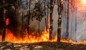
This week the national wildfire picture holds remarkably still, and the story worth telling is where the risk is moving rather than how much of it there is.
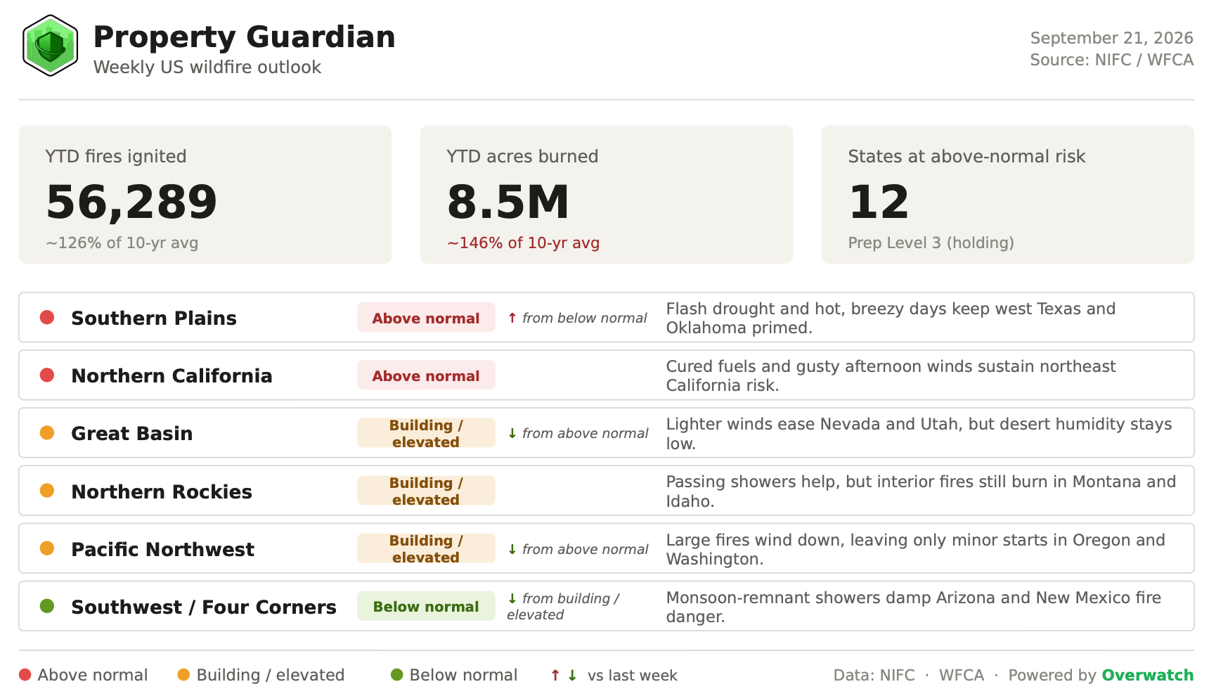
Year to date, 56,289 fires have burned about 8.5 million acres nationwide, roughly 126% of the ten-year average for fires and 146% for acreage, and NIFC is holding the National Preparedness Level at 3 for a second straight week.
Beneath that steady surface, the center of fire activity is sliding out of a cooling interior West and into a flash-drought-stricken southern Plains.
A quieter West, a restless South
The national dials barely moved this week: the Preparedness Level stays at 3 and the count of states at above-normal risk holds at 12.
The geography, though, rotated.
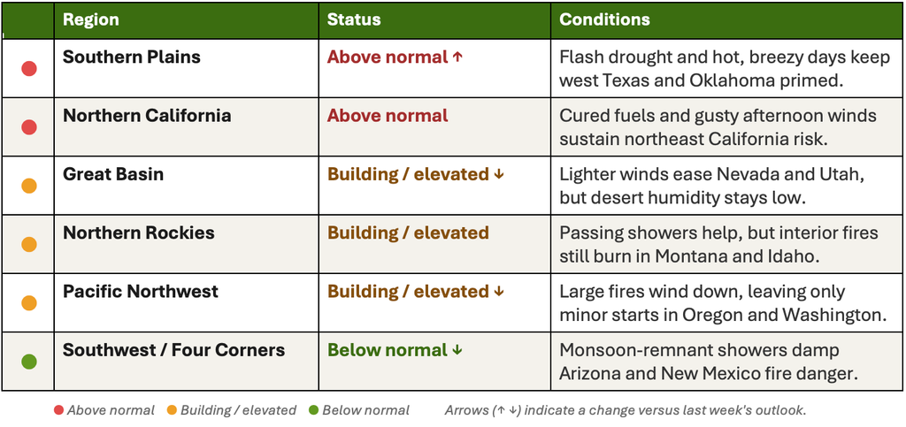
The Great Basin and the Pacific Northwest both step down from above normal as lighter winds and early-fall systems arrive, and the Southwest eases to below normal under lingering monsoon-remnant cloud cover.
Moving the other way, the southern Plains climb from below normal to above normal. NIFC’s latest monthly outlook flags an expansive band of above-normal significant fire potential across Texas, Oklahoma, Arkansas, Louisiana, Mississippi and southwestern Alabama, while northeast California remains the West’s one stubbornly above-normal pocket.
The days ahead: heat and wind on the southern Plains
The sharpest near-term threat sits over west-central and southwestern Oklahoma and western North Texas, where south winds of 10 to 15 mph gusting to 25, afternoon relative humidity down to 25 to 30% west of I-35, and highs near 100°F across the southern Plains and Mid-Mississippi Valley have driven fresh Red Flag Warnings.
Any new start in that drought-cured grass can move quickly. The West tells the opposite story: winds relax below 10 mph across the Mojave and southern Nevada, showers and isolated thunderstorms track through central Idaho and the northern Rockies, abundant cloud cover and isolated showers damp the Four Corners, and cooler air settles over California.
Looking further out, the Climate Prediction Center’s 6 to 10 and 8 to 14 day outlooks lean toward continued above-normal warmth and below-normal rainfall across the southern Plains, keeping the flash drought on an intensifying track.
The one to watch: the Dry River Fire
The marquee fire this week is the Dry River Fire on the Edwards Plateau, about six miles southwest of Sonora in Sutton County, Texas.
It ignited the afternoon of September 15 and has grown to roughly 8,939 acres at about 55% containment, drawing more than 100 firefighters from across the state. No injuries or destroyed structures have been reported and no evacuations are in place, though crews worked to keep the fire short of homes and briefly shielded the nearby I-10 corridor.
The Dry River Fire is a clean illustration of the week’s setup: drought-cured grass and brush, primed by heat and wind, in the exact zone NIFC now rates above normal.
Active fires across the country
The largest fires burning this week span the drought-stressed South and the winding-down interior West:
- Dry River (TX) — 8,939 acres, 55% contained. The largest actively burning fire in the country; it drew crews from across Texas and briefly menaced the I-10 corridor southwest of Sonora.
- Cascade (ID) — 7,475 acres, 70% contained. A backcountry fire in the Nez Perce-Clearwater National Forest, 19 miles east of Lowell.
- Willow (CO) — 7,389 acres, 80% contained. A high-country burn six miles west of Leadville, now closing in on full containment.
- Moose (MT) — 6,005 acres, 15% contained. The least-contained large fire in the Northern Rockies, 24 miles southwest of Philipsburg.
- Slough Canyon (UT) — 4,774 acres, 75% contained. Burning 41 miles east of Price on the Uintah and Ouray reservation.
- Lucas (CA) — 4,128 acres, 84% contained. Nearly wrapped up ten miles north of Upper Lake in the Northern California Coast Range.
- Bunker (AR) — 2,849 acres, 75% contained. A sign of the flash drought spreading east, two miles east of East Camden.
Regional Risk Outlook
Drought and El Niño in the background
The slow drivers keep the near-term picture in context.
As of mid-September, nearly 59% of the Lower 48 sits in drought, and a fast-building flash drought continues to intensify across the southern Plains and Lower Mississippi Valley, now reaching into the Southeast.
A strengthening El Niño, with a greater than 90% chance of a very strong event this fall and winter, tends to slow the Pacific storm season, which can hold the northwestern fire window open a little longer than the calendar suggests, even as it typically nudges the southern tier wetter later in the winter.
What it means for property owners, insurers, and risk teams
The takeaway this week is geographic rather than numerical: stop watching only the West.
National totals have flattened, but exposure is rotating toward Texas, Oklahoma and the Lower Mississippi Valley, where drought and wind are doing the work that the interior West’s fuels did all summer.
Portfolios concentrated across the southern Plains deserve a fresh look now, before conditions deepen. Property Guardian’s Overwatch tracks these shifts fire by fire and county by county, so underwriting and risk teams can act on where wildfire risk is heading, not where it was last month.
Sources
- NIFC National Fire News (YTD statistics, Preparedness Level, active fires)
https://www.nifc.gov/fire-information/nfn
NIFC Incident Management Situation Report
https://www.nifc.gov/nicc/sitreprt.pdf - NIFC/NICC Predictive Services monthly & seasonal outlook
https://www.nifc.gov/nicc-files/predictive/outlooks/monthly_seasonal_outlook.pdf - NOAA Storm Prediction Center fire weather outlooks
https://www.spc.noaa.gov/products/fire_wx/ - NOAA/NWS Red Flag Warnings (southern Plains / Texas)
https://www.weather.gov/ - NOAA Climate Prediction Center 6-10 day outlook
https://www.cpc.ncep.noaa.gov/products/predictions/610day/ - NOAA Climate Prediction Center 8-14 day outlook
https://www.cpc.ncep.noaa.gov/products/predictions/814day/ - U.S. Drought Monitor / Drought.gov (drought share, southern Plains flash drought)
https://www.drought.gov/national - NOAA CPC ENSO status (El Niño)
https://www.cpc.ncep.noaa.gov/products/analysis_monitoring/enso_advisory/ensodisc.shtml - Dry River Fire spotlight (Sonora, TX)
https://hoodline.com/2026/09/dry-river-fire-balloons-to-8-761-acres-near-sonora-threatens-i-10-corridor/
