
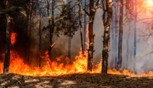
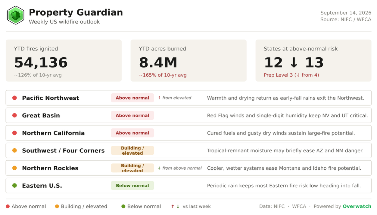
Fire season is moving at two speeds this week. Nationally it keeps winding down, with NIFC easing the National Preparedness Level to 3 and crews turning toward fuels work; 54,136 fires and 8.4 million acres have burned year-to-date, roughly 165% of the 10-year average. Across the interior West, though, Red Flag winds and a re-drying Pacific Northwest say the fire year still has teeth.
A two-speed week
The national gauges are all pointing down. NIFC opens the week at Preparedness Level 3, off last week’s 4 and the top-of-scale 5 that stood through most of August, and the count of states at above-normal risk slips to about a dozen from 13.
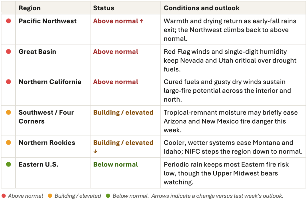
The regional picture is where the movement is: the Pacific Northwest climbs back to above normal as early-fall rain clears and fuels dry out east of the Cascades, while the Northern Rockies stand down as cooler, wetter systems settle over Montana and Idaho. The Great Basin and far Northern California hold above normal.
Where the danger is this week
The short-fuse forecast is the part worth planning around.
The Storm Prediction Center has critical, and in spots extreme, fire weather over the Great Basin, interior Northwest, and Rockies for the days ahead. Red Flag Warnings stretch across western Nevada, Utah, and northern Arizona, with southwest winds gusting 35 to 40 mph and relative humidity falling to 5 to 15% over severe-to-exceptional drought fuels; a separate Red Flag in northern California carries north-to-northwest winds of 20 to 35 mph and humidity of 10 to 20%.
Beyond that, the CPC 6-10 and 8-14 day outlooks lean warmer across the interior West for the back half of September, so a brief midweek lull is unlikely to close the season out.
Fire in focus: the Austin Fire
The week’s fire to watch is Oregon’s Austin Fire, burning in the Mount Hood National Forest southeast of Estacada across parts of Clackamas, Marion, and Wasco counties, in steep, timbered country. It has reached 12,879 acres at 56% containment, a large jump from 19% earlier in the month, but crews are still working active flanking, backing, and torching, with residences and energy infrastructure threatened and area, road, and trail closures in place. Investigators have confirmed a human cause.
What makes it the marquee incident is where it sits. NIFC keeps the Northwest above normal for September, and with early-fall rains clearing, warmth forecast to rebuild east of the Cascades, and a real chance of an east-wind day later in the month, a fire only just past half-contained is the kind that can find new life fast.
For carriers, it is a clean illustration that late-season containment can slip the moment the wind turns, and that a calmer national picture does not lower the risk on any single active perimeter.
Still on the line
More than a dozen states still had large fires burning as the week opened, most of them clustered across the Northwest. The ones drawing the most attention:
- Big Grass Fire, Oregon — 578,637 acres, 94% contained. The season’s largest fire, lightning-caused near the Oregon-Idaho border on July 23 and now all but wrapped after more than seven weeks on the line.
- Crosswhite Fire, Oregon — 342,923 acres, 92% contained. One of four Oregon fires among the country’s ten largest this year, now deep into mop-up and suppression repair.
- Little Giant Fire, Washington — 172,695 acres, 81% contained. A lightning fire burning since mid-July near Leavenworth; crews are reinforcing the Twin Lakes perimeter ahead of a forecast warming trend.
- Austin Fire, Oregon — 12,879 acres, 56% contained. Human-caused and still active in the Mount Hood corridor southeast of Estacada, with homes and energy infrastructure threatened (see focus above).
- Sisi Fire, Washington — 3,193 acres, 11% contained. A lightning fire about eight miles northwest of Stehekin, the least contained on this list and burning in rugged, hard-to-reach terrain.
What’s driving the backdrop
Underlying it all is still a drought-hardened West: roughly 57% of the Lower 48 remains in drought, with Extreme-to-Exceptional (D3-D4) conditions across the northern Rockies and interior Great Basin. Further out, CPC now puts the odds of a strong El Niño developing through fall and winter above 90 percent, a signal worth watching for how it reshapes precipitation into the late-season fire outlook.
Regional Risk Outlook
The season behind the numbers
The slow-moving backdrop has barely budged. Drought still covers close to 57% of the country, with pockets of exceptional drought across Oregon, the eastern Great Basin, and the central Rockies.
A rapidly strengthening El Niño, which the CPC expects to reach very strong and possibly the strongest on record by November, is starting to shape the pattern, nudging the West toward a wetter late fall while offering little in the near term.
What it means for underwriting and risk teams
A softer national number is not an all-clear.
A Preparedness Level down two weeks running is genuinely good news, but a re-firing Pacific Northwest, Red Flag winds in the Great Basin, and fuels still cured across the interior West make the coming week one for confirming exposure, checking defensible space, and keeping active-fire monitoring switched on rather than winding it down.
Property Guardian’s Overwatch platform tracks these conditions and active-fire perimeters in near real time, so underwriting and risk teams can put attention on the days and locations that carry the most exposure.
Sources
- NIFC National Fire News
https://www.nifc.gov/fire-information/nfn - NIFC Incident Management Situation Report
https://www.nifc.gov/nicc-files/sitreprt.pdf - NIFC National Significant Wildland Fire Potential Outlook (Sept–Dec 2026)
https://www.nifc.gov/nicc-files/predictive/outlooks/monthly_seasonal_outlook.pdf - NIFC Fire Statistics (year-to-date)
https://www.nifc.gov/fire-information/statistics - NOAA Storm Prediction Center Fire Weather Outlooks
https://www.spc.noaa.gov/products/fire_wx/ - NWS Red Flag Warnings (Nevada / Utah / Northern California, Sept 11–14, 2026)
https://forecast.weather.gov/wwamap/wwatxtget.php?cwa=usa&wwa=Red+Flag+Warning - NOAA CPC 6-10 Day Outlook
https://www.cpc.ncep.noaa.gov/products/predictions/610day/ - NOAA CPC 8-14 Day Outlook
https://www.cpc.ncep.noaa.gov/products/predictions/814day/ - NOAA CPC ENSO Diagnostic Discussion
https://www.cpc.ncep.noaa.gov/products/analysis_monitoring/enso_advisory/ensodisc.shtml - U.S. Drought Monitor
https://droughtmonitor.unl.edu/ - Austin Fire (InciWeb)
https://inciweb.wildfire.gov/incident-information/ormhf-austin-fire - Little Giant Fire (InciWeb)
https://inciweb.wildfire.gov/incident-information/waowf-little-giant-fire - Big Grass Fire (InciWeb)
https://inciweb.wildfire.gov/incident-information/orvad-big-grass-fire - Newsweek — Map Shows Largest Active Wildfires in US Right Now
https://www.newsweek.com/map-largest-active-wildfires-in-united-states-right-now-12342921
