

The Quick Read
More than 8.2 million acres had burned across the United States by August 31, roughly 166 percent of the ten-year average, across more than 52,000 fires. Drought now covers nearly 57 percent of the country. The National Interagency Fire Center’s fall outlook keeps northeastern California above normal through September, with very dry fuels at all elevations and Santa Ana winds set to intensify into October.
The geography of the risk is shifting late in the year, away from the summer Pacific Northwest and Northern Rockies and toward wind-driven autumn events in California. For commercial portfolios built on the assumption that fire season ends at Labor Day, that late shift is where the accumulation surprise hides.
How Property Guardian Helps: Our active fire intelligence and portfolio-level exposure views let commercial teams watch accumulation build in real time, so a late-season wind event becomes a monitored, managed exposure rather than a surprise on the loss run.
It is tempting to treat Labor Day as the unofficial close of fire season. The 2026 numbers argue otherwise, and so does the physics of autumn in the West. The season is not winding down so much as relocating, and where it is heading matters more to commercial property portfolios than the raw acreage that has already burned.
What the Numbers and the Outlook Say
Through August 31, some 8,238,284 acres had burned nationally across 52,253 reported fires, running at about 166 percent of the previous ten-year average. Drought expanded sharply over the summer and now covers close to 57 percent of the country, keeping fuels primed across large stretches of the West.
The National Interagency Fire Center’s fall outlook is not uniform, and that is the point. Across the Pacific Northwest, the western Northern Rockies and much of Northern California’s high country, large-fire potential is easing as cooler showers move through. But significant fire potential stays above normal across northeastern California into September, where very dry fuels at all elevations and ongoing drought continue to support large, long-duration incidents. High risk also persists in northern Baja California as Santa Ana winds intensify through September and October. The Idaho Panhandle, having received little to no summer moisture, remains in severe drought.
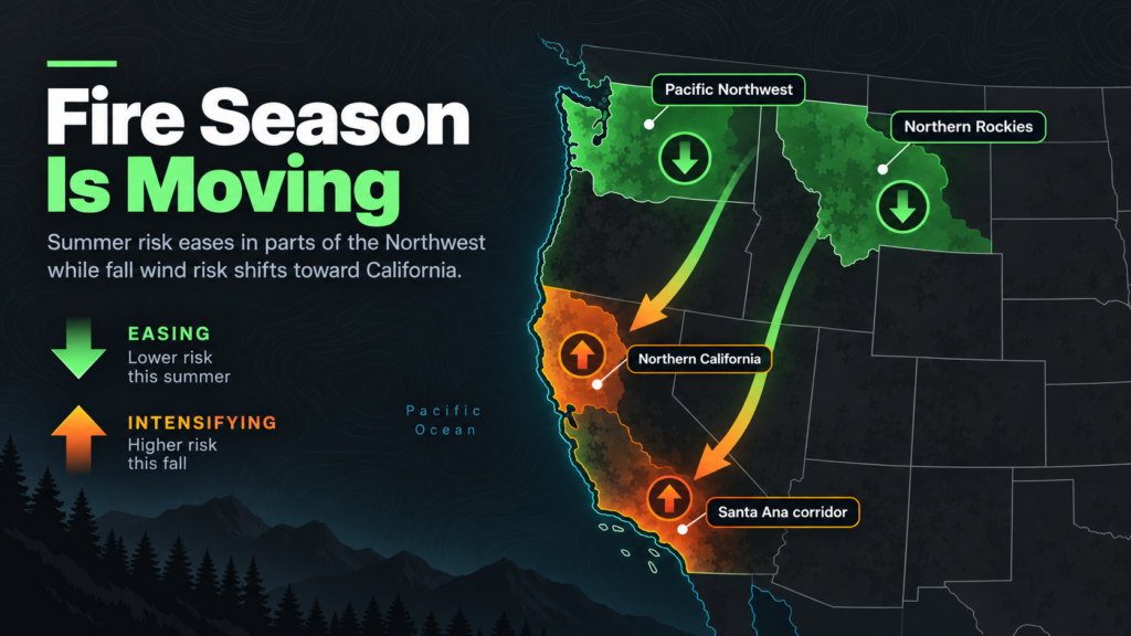
The forecast track adds to the picture. Storms this fall are expected to drop down the West Coast rather than push inland into the Pacific Northwest, and most are likely to be warm, with the potential for more atmospheric rivers than normal. In plain terms, the moisture and the wind are not arriving in the same places at the same time, which is exactly the setup that produces wind-driven autumn fire.
Why This Should Move Commercial Thinking, Not Just Headlines
The season’s late geography is the story. Summer risk concentrated in the Pacific Northwest and Northern Rockies is giving way to wind-driven events in California and, as the calendar turns, Southern California. A portfolio that treats California wildfire as a July-and-August problem can be caught flat by an October Santa Ana event.
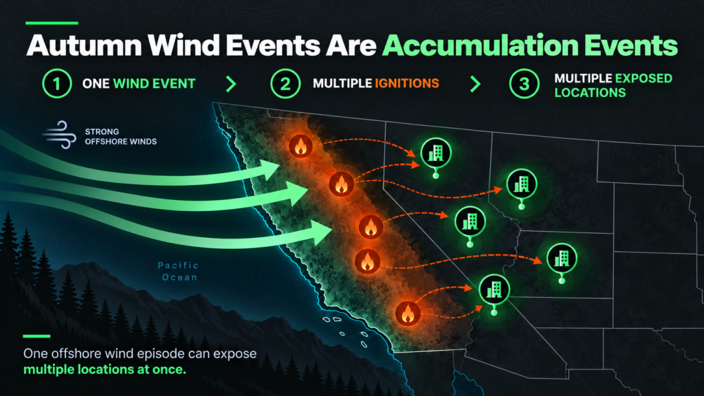
That matters because autumn wind events are accumulation events. A single offshore wind episode can push multiple ignitions across a wide footprint at once, exposing many insured locations in the same event rather than one megafire in one basin. For teams managing concentration, the relevant stress test late in the year is not a single large summer fire but a wind-driven event that touches a cluster of exposures simultaneously.
There is a model-year overlay as well. With national burn running well above the ten-year average, 2026 loss experience will read hot, and that feeds directly into cat-load and reinsurance conversations at renewal. Underwriters who can show that they monitored and managed late-season accumulation, rather than assuming the season had ended, will be in a stronger position in those discussions.
It is also worth remembering how uneven this season has been. A near-record national burn does not mean every region shared the pain equally, and that unevenness is exactly what makes portfolio accumulation so hard to intuit. A book that came through the summer clean can still carry meaningful autumn exposure if its locations happen to cluster in the wind corridors that light up in October and November. Aggregate calm across a portfolio can quietly mask concentrated risk in a handful of ZIP codes, and a single offshore wind event is what turns that hidden concentration into a correlated loss.
Practical Takeaways for Underwriters, Risk Managers and Operators
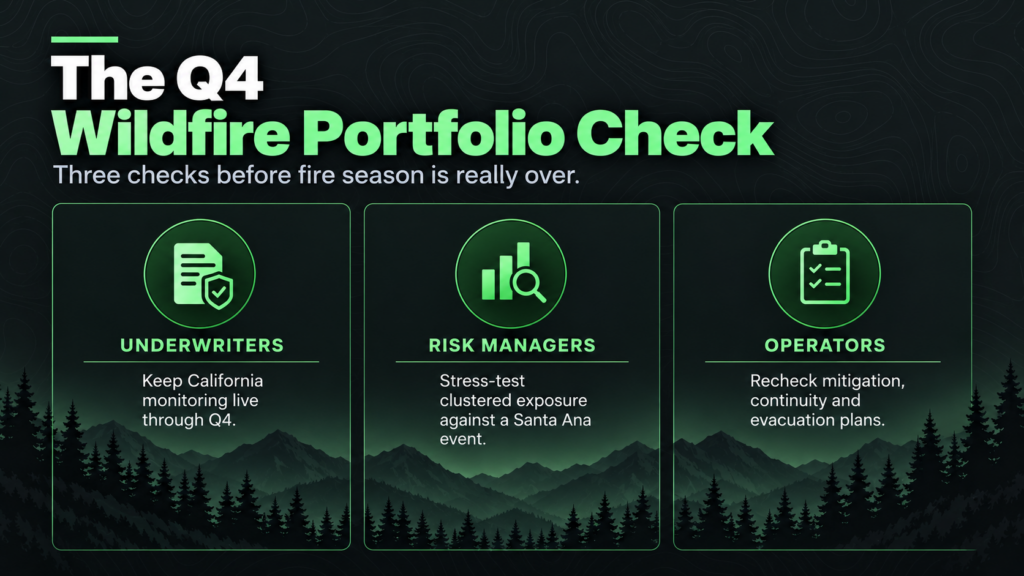
For underwriters, the immediate action is to keep California and Southern California exposure monitoring live through the fourth quarter rather than standing it down after Labor Day. Wind-driven ignition, not summer heat, is the late-season driver, and it deserves the same attention in October that flame-front risk got in August.
For risk managers, this is a prompt to stress-test accumulation against a single Santa Ana wind event that hits several locations at once, and to track fuel dryness and the drought footprint as leading indicators heading into renewals. Those indicators are available now and tend to move before the loss experience does.
For the operators of insured commercial properties in exposed areas, the autumn wind window is the time to revisit business-continuity and evacuation plans, confirm that on-site mitigation is intact after a long dry summer, and make sure vendor and tenant continuity arrangements can survive a fast-moving, wind-driven event.
How Property Guardian Fits
The hard part of late-season risk is not knowing that autumn fire happens. It is seeing, in the moment, where a wind-driven event is building against your specific book. Property Guardian’s active fire intelligence and portfolio-level exposure and accumulation views give commercial teams that real-time line of sight, turning a late-season Santa Ana from a surprise on the loss run into an exposure that was watched, quantified and managed as it developed.
Sources
National Interagency Fire Center, National Fire News and monthly/seasonal outlooks (2026)
