
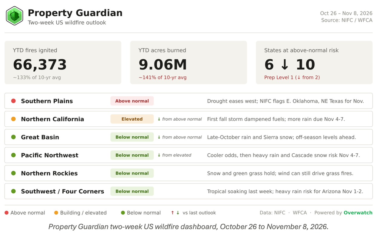
Preparedness Level 1. NIFC lowered the national level to the bottom of its five-step scale on October 14, and this outlook opens there. The 2026 fire year stands at 66,373 fires and 9,059,044 acres as of October 25, roughly 133% and 141% of the 10-year average for the date. Those totals will barely move from here. What is moving is the map: the West just absorbed its first traditional storm of the fall, and the risk that remains is sliding east toward the Mid-South, where drought is still getting worse.
What moved since the last outlook
By our read, the count of states at above-normal risk falls from 10 to 6, and every change on the map points the same direction.
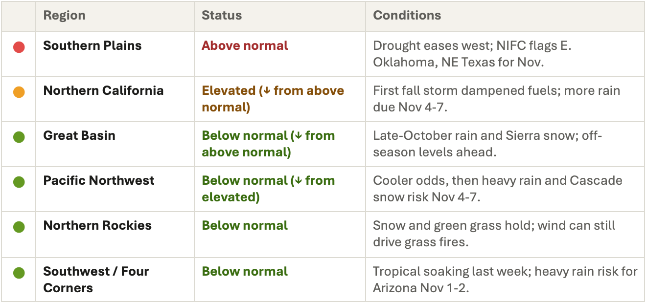
The Great Basin drops two tiers to below normal: the October 21 to 23 storm, fed by moisture from the remnants of Hurricane Trudy, brought widespread rain and up to a foot of Sierra snow in the forecasts, ending the Sierra Front dry streak that put western Nevada above normal two weeks ago.
NIFC already expected the Great Basin to settle to off-season levels from late October on. Northern California eases to elevated, since the storm dampened fuels but low-elevation grass stays cured until the steady rains arrive, and the Pacific Northwest slips from elevated to below normal. The Southern Plains hold above normal, but the center of gravity is shifting.
The October 22 Drought Monitor showed improvement across the Southern Plains and Four Corners while drought worsened again in the Lower Mississippi basin. NIFC’s November outlook puts above-normal significant fire potential from eastern Oklahoma and northeast Texas into Arkansas, north Mississippi, west and middle Tennessee, and Kentucky, areas that tend to run dry in strong El Niño years. Those six states are our count for this outlook.
The weather between now and November 8
Through Halloween. Most of the West opens dry and mild while fuels hold last week’s moisture; forecasts for Las Vegas, for example, call for sunny upper-70s days through October 30. CPC’s October 22 outlooks favored below-normal temperatures in Washington, Oregon, and Montana for October 28 to November 1.
We found no widespread Red Flag setup in the forecasts we reviewed for the opening days, but the Northern Rockies offer a reminder of how quickly that changes: on October 23, NWS posted a Red Flag Warning for Sheridan County, Montana, with southwest winds of 20 to 30 mph gusting to 45 mph on dry, unseasonably warm air.
East of the Rockies, CPC’s 8-14 day outlook (October 30 to November 5) favors above-normal temperatures for most of the country, which keeps the Mid-South drying as leaf drop adds fresh surface fuel.
November 1 to 8. CPC’s week-two hazards outlook, issued October 24, turns wet almost everywhere fire has been a concern this fall. It carries a moderate risk of heavy precipitation for parts of Arizona and adjacent New Mexico on November 1 and 2, with flooding possible, plus a slight risk for coastal southern California the same days.
From November 4 to 7 the storm track shifts north, with a slight risk of heavy precipitation for the Pacific Northwest and northern California, heavy snow for the Cascades, Klamath, and northern Sierra, and high winds along the Northwest coast. A slight risk of heavy rain also covers the Southern Plains, the Lower and Middle Mississippi, Ohio, and Tennessee valleys, and the Southeast from November 1 to 4, but CPC notes the European ensemble has backed off that signal and the earlier moderate risk was dropped. That is the least certain rain on the map, and it is the rain the Mid-South needs most.
The last western holdout
The Sisi Fire is small, slow, and stubborn. A lightning start in the North Cascades about 10 miles northwest of Stehekin, on the Okanogan-Wenatchee National Forest, it has been backing and flanking through closed timber since mid-August. It stood at 4,275 acres and 15% contained on September 25, 4,439 acres and 34% on October 12, and 4,743 acres and 34% in NIFC’s October 23 report: steady growth of a few hundred acres every couple of weeks, with residences in the area listed as threatened and parts of the Stehekin Valley Road closed since early September.
It is now the least-contained large fire in the country, and the forecast finally lines up against it. Cooler-than-normal odds for Washington to close October, then CPC’s November 4 to 7 signal for heavy precipitation and Cascade snow, describe the kind of event that typically ends a fire season in the North Cascades. If that storm arrives as forecast, Sisi is likely to be the last western fire on this list.
Open line on the map
NIFC counted 10 large fires on October 23, with 1,614 personnel assigned. Most of the season’s big incidents, including Timber in California and Austin in Oregon, are at 95% containment or better and have dropped off this list, as has the Cooley Fire near Lake Sonoma. The remaining open line is scattered from Washington to Florida:
- Sisi (WA) — 4,743 acres, 34% contained. Ten miles northwest of Stehekin in the North Cascades; lightning-caused and still growing slowly after more than two months.
- Bee Haven 2 24-06 (FL) — 2,060 acres, 80% contained. Twenty-eight miles northwest of Lake City on Florida Forest Service land, with short-range spotting reported.
- Ridge (MI) — 466 acres, 50% contained. Six miles north of Negaunee in the Upper Peninsula, inside the drought area NIFC flagged above normal for October.
- Black River (MI) — 326 acres, 75% contained. Four miles south of Wakefield in the western Upper Peninsula, managed by the Michigan DNR.
- Kickapoo Creek (TX) — about 300 acres, 50% contained. Sixteen miles east of Trinity in east Texas, reported October 22 with active fire behavior threatening structures.
Regional risk outlook
Backdrop: less drought, a record El Niño
Drought covers 50.67% of the Lower 48 in the October 22 Drought Monitor, down from about 55% at our last outlook. El Niño keeps building, with CPC giving it a 75% chance of surpassing the strongest event since 1950, a pattern that favors a wetter winter across the southern tier but often leaves the Mid-South and Ohio Valley dry in the fall.
Sources
- NIFC National Fire News (October 23, 2026)
https://www.nifc.gov/fire-information/nfn - NIFC Statistics (updated October 25, 2026)
https://www.nifc.gov/fire-information/statistics - NIFC Predictive Services Outlooks
https://www.nifc.gov/nicc/predictive-services/outlooks - National Significant Wildland Fire Potential Outlook (issued October 1, 2026)
https://www.nifc.gov/nicc-files/predictive/outlooks/monthly_seasonal_outlook.pdf - CPC U.S. Week-2 Hazards Outlook (made October 24, 2026)
https://www.cpc.ncep.noaa.gov/products/predictions/threats/threats.php - WPC Day 3-7 Hazards Outlook
https://www.wpc.ncep.noaa.gov/threats/threats.php - Forbes: U.S. Midterm Election Day Weather, a 10-day forecast (CPC 8-14 day summary)
https://forbes.com/sites/marshallshepherd/2026/10/23/a-first-look-at-the-us-midterm-election–day-weather-forecast - Meteored: NWS maps show flooding rain, mountain snow and cooler conditions this week
https://www.theweather.com/news/forecasts/nws-maps-show-flooding-rain-mountain-snow-and-cooler-conditions-this-week-for-california-and-the-southwest.html - Rolling Out: Wildfire danger spikes in Montana as strong winds arrive (Sheridan County Red Flag Warning)
https://rollingout.com/2026/10/22/sheridan-county-red-flag-fire-warning/ - The Weather Channel: Santa Ana winds boost danger as fires prompt evacuations
https://weather.com/2026/10/17/forecast/regional/california-wildfire-threat-santa-ana-winds - Drought.gov: Drought Status Update for the Southern Plains (October 22, 2026)
https://www.drought.gov/drought-status-updates/drought-status-update-southern-plains-2026-10-22 - Drought.gov: National Drought Status
https://www.drought.gov/national - WFCA: Tracking the Kickapoo Creek Fire in Texas
https://wfca.com/fire-map/texas/kickapoo_creek - Cal Fire: Cooley Fire
https://www.fire.ca.gov/incidents/2026/10/16/cooley-fire/ - KPBS: Henderson Fire at Camp Pendleton reaches 95% containment
https://www.kpbs.org/news/2026/10/19/henderson-fire-at-camp-pendleton-reaches-95-containment-at-3-260-acres - Sisi Fire tracker
https://currentwildfires.com/en/fire/sisi-fire-wa-2026/
