
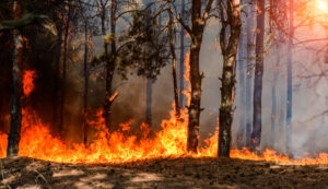
On Sunday the Dome Fire added 475 acres inside Yosemite, burning north through dead timber left by the 2017 Empire Fire. At about 5,000 acres it is small by this summer’s standards, but it sits squarely under the pattern that will shape the next two weeks: a western ridge building heat and dryness into mid-October while the southern tier turns wetter.
Nationally the season keeps easing. NIFC opens this stretch at National Preparedness Level 2, down from 3 in our last outlook, with 57,339 fires and roughly 8.56 million acres burned in 2026 (124% and 142% of the 10-year average for this date). On Property Guardian’s regional read, states at above-normal risk fall from 12 to 10 as Texas and Oklahoma step down.
With activity slowing, this outlook now publishes every two weeks, each edition covering the fortnight ahead.
The fire under the ridge
The Dome Fire has been growing steadily since mid-September: 4,258 acres on September 25, 4,606 on the 27th, and 5,081 by Monday morning, with 808 personnel assigned and containment targeted for October 17.
It is burning in the Yosemite Wilderness north of Wawona Dome in timber, brush, and heavy slash, with uphill runs and single-tree torching. The park notes that heavy dead and fallen trees can throw embers ahead of the fire, and that higher humidity has been what keeps those embers from catching.
That humidity is what the next two weeks are likely to take away. The fire is moving away from Wawona, and park officials report no immediate threat to roads, buildings, or utilities, but crews are clearing brush around homes in Wawona and Yosemite West and Glacier Point Road remains closed.
A long run of warm, dry days under the ridge gives a slow fire in heavy fuels time to work, which makes the Dome Fire the one to watch as October goes on.
Days 1 to 7: Polo’s rain, the West stays dry
Moisture from Hurricane Polo dominates the first week. NIFC Predictive Services expects widespread showers, scattered thunderstorms, and localized flooding across the Southwest, spreading into the central Rockies and much of the central and northern Plains, and some Southwest locations could collect 3 to 5 inches of rain. In the southern Plains, Gulf moisture keeps afternoon humidity above 35% with isolated storms.
California, the western Great Basin, the Northwest, and the northern Rockies stay dry, though temperatures there start below normal and winds are mostly light.
Days 8 to 14: the West warms and dries
The second week is where the risk shifts.
CPC’s latest 6-10 day outlook (October 4 to 8) gives better than 80% odds of above-normal temperatures across a large part of the western US and high odds of below-normal precipitation across the northwestern and north-central states.
The 8-14 day outlook (October 6 to 12) keeps the ridge in place: warmth favored across the West, below-normal precipitation favored from Washington, Oregon, and northern California through Idaho, Nevada, Utah, Colorado, Montana, and Wyoming. The southern tier goes the opposite way, with above-normal precipitation likely for most of Texas and favored along the Gulf Coast and Southeast.
The slower backdrop holds: 59% of the Lower 48 remains in drought, with exceptional drought across much of northern Texas and western to southern Oklahoma, and CPC gives the strengthening El Niño a 75% chance of reaching historic strength this fall and winter.
Large fires to track
- Dome (CA) — 5,081 acres, 30% contained. Working north through the 2017 Empire Fire footprint in the Yosemite Wilderness, with Glacier Point Road closed and containment targeted for October 17.
- Little Giant (WA) — 172,891 acres, 81% contained. Thirty miles northwest of Leavenworth; NIFC lists 40 structures lost, and the fire is now mostly smoldering.
- Sinlahekin (WA) — 166,007 acres, 93% contained. One mile west of Tonasket; 33 structures lost, with crews in mop-up.
- Timber (CA) — 25,349 acres, 77% contained. Southeast of Big Sur on the Los Padres National Forest; numerous structures still threatened and costs near $170 million.
- Three Queens (WA) — 9,575 acres, 32% contained. East of Snoqualmie Pass, with numerous residences and critical infrastructure threatened.
- Sisi (WA) — 4,325 acres, 15% contained. Northwest of Stehekin in closed timber, still backing and flanking with residences threatened.
- Rafter 4B (TX) — 2,100 acres, 50% contained. Southeast of Eldorado; grew 850 acres in a day over the weekend before fire behavior moderated.
- Second Street (WA) — 1,151 acres, 95% contained. The wind-driven grass fire near Benton City that closed I-82 and destroyed seven structures on September 25.
Regional risk outlook
What a slower season still asks of risk teams
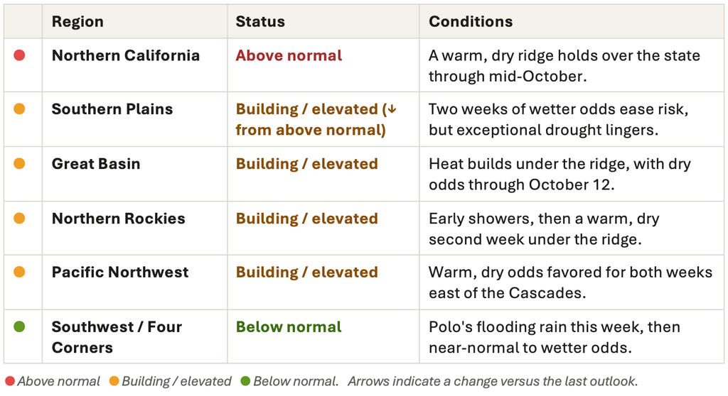
For property owners, insurers, and risk managers, a lower Preparedness Level is not the same as a closed season. The next two weeks point to fire risk concentrating in the West, where northern California, the Great Basin, and the interior Northwest head into mid-October warm and dry, while rain buys the southern Plains time without ending the drought underneath.
Property Guardian’s Overwatch keeps watch between outlooks, flagging new starts and the properties around them as they happen, so teams are not waiting two weeks to see their exposure change.
Sources
- NIFC Incident Management Situation Report, September 28, 2026
https://www.nifc.gov/nicc-files/sitreprt.pdf - NIFC National Fire News
https://www.nifc.gov/fire-information/nfn - NIFC Predictive Services Outlooks
https://www.nifc.gov/nicc/predictive-services/outlooks - NOAA Climate Prediction Center, 6-10 and 8-14 Day Outlook Discussion (issued September 28, 2026)
https://www.cpc.ncep.noaa.gov/products/predictions/610day/fxus06.html - NOAA Climate Prediction Center, ENSO Diagnostic Discussion
https://www.cpc.ncep.noaa.gov/products/analysis_monitoring/enso_advisory/ensodisc.shtml - U.S. Drought Monitor
https://droughtmonitor.unl.edu/ - Drought Monitor Update, September 24, 2026
https://www.yahoo.com/news/weather-news/articles/drought-monitor-september-24th-2026-142459857.html - National Park Service, Dome Fire Update, September 25, 2026
https://www.nps.gov/yose/learn/news/dome-fire-update-september-25-2026-morning.htm - The Weather Channel, “Hurricane Polo’s moisture could lead to major flooding in Southwest”
https://weather.com/2026/09/28/forecast/regional/hurricane-polo-southwest-moisture-flash-flooding - Apple Valley News Now, “Level 3, 2 evacuations remain in place, roads closed for Second Street Fire near Benton City”
https://www.applevalleynewsnow.com/news/evacuations-remain-in-place-roads-closed-for-second-street-fire-near-benton-city/article_7cf3c3b2-2bd3-4a85-b966-5178fde6bfb2.html - WFCA Fire Map
https://wfca.com/fire-map/
