
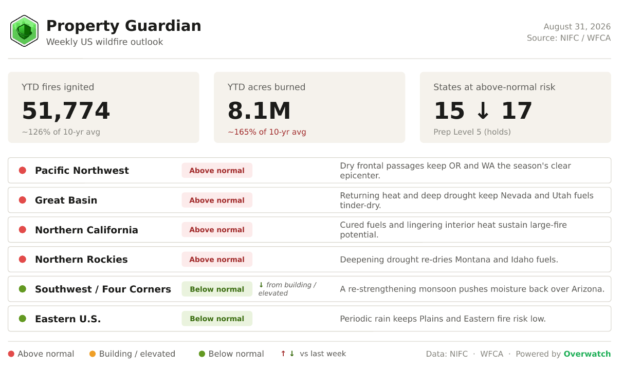
The US enters this week deep in an elevated stretch of fire season: more than 8.1 million acres have already burned year-to-date, roughly 165% of the 10-year average, across 51,774 fires nationwide, and the week ahead points to fire risk narrowing toward a still-dangerous Inland Northwest core.
Heading Into This Week
NIFC opens the week at National Preparedness Level 5, the top of the scale, holding there with more than 29,000 personnel committed to fires nationwide.
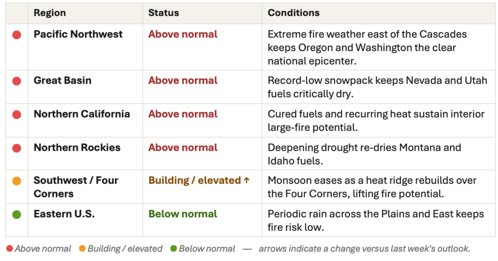
The count of states at above-normal risk eases from 17 to about 15 as the calendar turns to September and the peak-August footprint begins to contract. The Southwest and Four Corners step down from building/elevated to below normal as a re-strengthening monsoon returns moisture to Arizona, while the Pacific Northwest, Great Basin, Northern California and Northern Rockies all hold above normal, keeping the West’s core the story the week opens with.
Fire weather for the week ahead
The near-term hazard shifts inland after last week’s Particularly Dangerous Situation Red Flag Warnings, the first of the season for the Pacific Northwest, when a dry cold front drove extremely critical fire weather and gusts near 40 mph across central and eastern Washington and north-central Oregon.
Heading into this week, NWS Boise has posted a Fire Weather Watch from August 31 through September 3 across a dozen Idaho zones, from the Owyhee Mountains and Treasure Valley to the Payette and Boise national forests, with critical conditions possible as returning heat and low humidity meet gusty winds (regional Red Flag criteria trip at relative humidity at or below 15% with gusts of 25 to 30 mph).
Farther south, the CPC 6-10 and 8-14 day outlooks favor enhanced monsoonal moisture over Arizona, extending into Utah and the northern Rockies, nudging the worst heat eastward and offering the Southwest genuine relief even as the Great Basin and southern Idaho re-dry.
Fire spotlight
The week’s marquee fire remains the Sinlahekin Fire in Okanogan County, Washington, burning in the timber and brush west of Tonasket. Now the state’s largest fire of 2026, it has burned 166,868 acres and is 41% contained, with roughly 1,690 personnel assigned.
Lightning-ignited on July 26 about 12 miles west of Tonasket, the fire has stalled in recent days with no measurable growth, yet its containment is the lowest among the season’s megafires, and Level 3 ‘Go Now’ evacuations remain in place west of the Okanogan River from north of Tonasket toward Oroville, including Palmer Mountain.
The near-term concern is weather, not fuel: continued dry, breezy frontal passages across north-central Washington can push the uncontained northwestern flank before crews fully close the line.
For insurers and risk managers, Sinlahekin is a reminder that a fire can hold flat on acreage for days and still carry active exposure, so containment percentage alone is a poor proxy for when to stand down.
Major Fires We’re Watching This Week
These are the largest and most consequential fires shaping the national picture as the week opens:
- Big Grass Fire (OR): 578,637 acres, 94% contained. Lightning-ignited July 23 in Malheur County, it is one of the largest fires of the 2026 season and is now in final consolidation, holding its lines with no new growth.
- Rowe Creek Complex (OR): about 374,000 acres, 93% contained. A cluster of lightning fires sparked by a July 15-16 storm near Twickenham; evacuations across Crook and Wheeler counties have been lifted or downgraded.
- Sinlahekin Fire (WA): 166,868 acres, 41% contained. Washington’s largest fire of the year, with Level 3 evacuations still in force west of the Okanogan River toward Oroville.
- Aspen Acres Fire (CO): 102,004 acres, 82% contained. Holding steady with no new acreage and a stable containment perimeter.
- Gold Mountain Fire (CO): 39,744 acres, 92% contained. Nearly wrapped, with steady containment gains and no active perimeter growth.
What’s driving the backdrop
Underlying it all is still a drought-hardened West: about 57% of the Lower 48 was in drought as of late August, with Extreme (D3) drought expanding across southern Oregon and northern Washington and Extreme-to-Exceptional (D4) drought pushing into northeastern Idaho. The one bright spot is the monsoon, which is re-strengthening over Arizona and easing the Southwest even as heat and dryness rebuild farther north.
Regional Risk Outlook
What This Means for Property Owners, Insurers, and Risk Managers
For property owners, insurers, and risk managers, a Preparedness Level pinned at 5 and four Western regions still above normal mean the week ahead is the time to verify exposure and harden assets, not to relax because the calendar has flipped to September.
The season’s risk is narrowing rather than ending: as the footprint contracts toward the Inland Northwest, the fires that remain are concentrated where fuels are driest and containment is hardest-won.
Property Guardian’s Overwatch platform tracks these shifts in near-real time so teams can focus attention where active exposure is genuinely rising.
Sources
- NIFC National Fire News
https://www.nifc.gov/fire-information/nfn - NIFC Statistics (YTD fires and acres)
https://www.nifc.gov/fire-information/statistics - NIFC National Significant Wildland Fire Potential Outlook
https://www.nifc.gov/nicc-files/predictive/outlooks/monthly_seasonal_outlook.pdf - SPC Fire Weather Outlooks
https://www.spc.noaa.gov/products/fire_wx/ - KATU — PNW “extremely critical” fire weather / PDS Red Flag Warnings
https://katu.com/news/local/pacific-northwest-faces-extremely-critical-fire-weather-risk-as-winds-near-40-mph-oregon-washington-cascades-pendleton-spokane-bend-redmond-prineville-john-day-madras-pds-red-flag-warning - NWS Boise Red Flag / Fire Weather Watch (WWA summary)
https://forecast.weather.gov/wwamap/wwatxtget.php?cwa=boi&wwa=red+flag+warning - NOAA CPC 6-10 day outlook
https://www.cpc.ncep.noaa.gov/products/predictions/610day/ - NOAA CPC 8-14 day outlook
https://www.cpc.ncep.noaa.gov/products/predictions/814day/ - U.S. Drought Monitor
https://droughtmonitor.unl.edu/ - Drought.gov current conditions
https://www.drought.gov/current-conditions - Sinlahekin Fire update (spotlight)
https://firerisk.ai/fire/sinlahekin-fire/latest-news - Big Grass Fire update
https://firerisk.ai/fire/big-grass-fire/latest-news - Rowe Creek Complex (InciWeb)
https://inciweb.wildfire.gov/incident-information/orprd-rowe-creek-complex
