
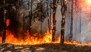
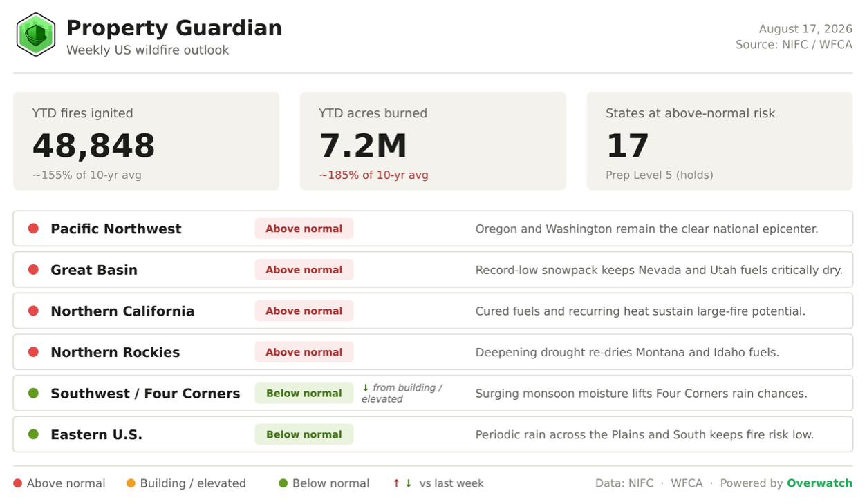
A fifth straight week at the nation’s top fire alert, and the acreage still isn’t easing off. About 7.2 million acres have burned so far in 2026 across nearly 48,900 fires, running near 185% of the 10-year average. The maps opening this week keep the West firmly in charge, though the Southwest finally catches a break as monsoon rain arrives.
Heading Into This Week
Not much has moved at the top line. NIFC stays at Preparedness Level 5 for a fifth straight week, and the count of states at above-normal risk is unchanged at 17.
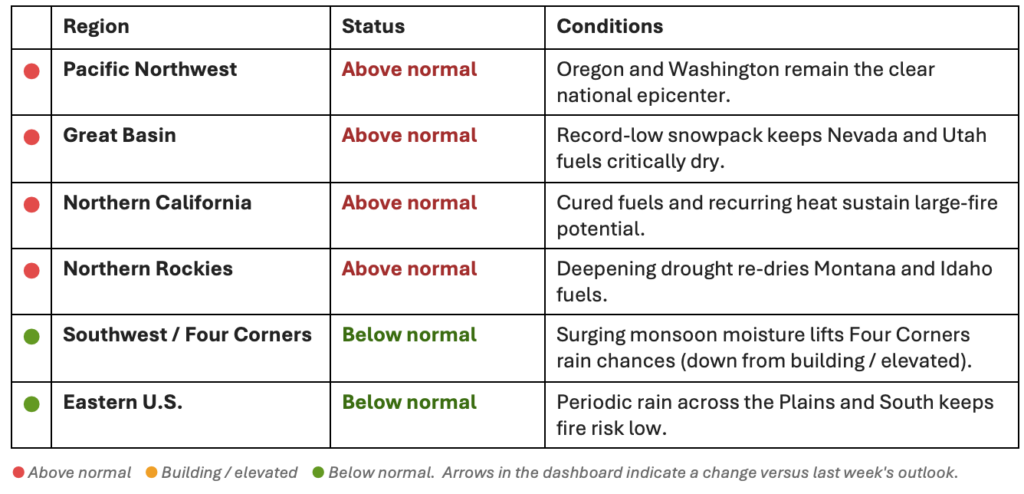
The West is still where the season lives, with the Pacific Northwest anchoring the national picture and the Great Basin, Northern California, and Northern Rockies all above normal.
The one change worth flagging is the Southwest / Four Corners, which slides from building/elevated down to below normal as monsoon moisture floods in.
Fire weather for the week ahead
The near-term forecast is where the action is.
Elevated-to-critical fire weather is drawn over the northern Great Basin, Central Rockies, and interior Northwest for the days ahead, with dry lightning possible across the Desert Southwest, northern Rockies, and northern Washington.
The sharpest threat sits in the Lower Columbia Basin of Oregon and Washington, under Red Flag Warnings for west winds of 25 to 35 mph, gusts to 45, and humidity bottoming out near 20% with little overnight recovery.
Beyond day 5, CPC guidance leans wetter across the Southwest and Great Basin as the monsoon ramps up, though the heat stays stubbornly above normal almost everywhere else.
Fire spotlight
The fire making real runs right now is the Little Giant Fire, burning in steep, timbered Cascade terrain about 30 miles northwest of Leavenworth, in the Chiwawa and Entiat river country near Lake Chelan and the Glacier Peak Wilderness. Sparked in mid-July, it has grown explosively, more than doubling in five days to roughly 132,000 acres, and sits at just 10% containment with more than 1,800 firefighters assigned across Chelan and Okanogan counties. It has already destroyed about two dozen structures, including homes, and Level 3 “Go Now” evacuations are in effect on the south side of the lake.
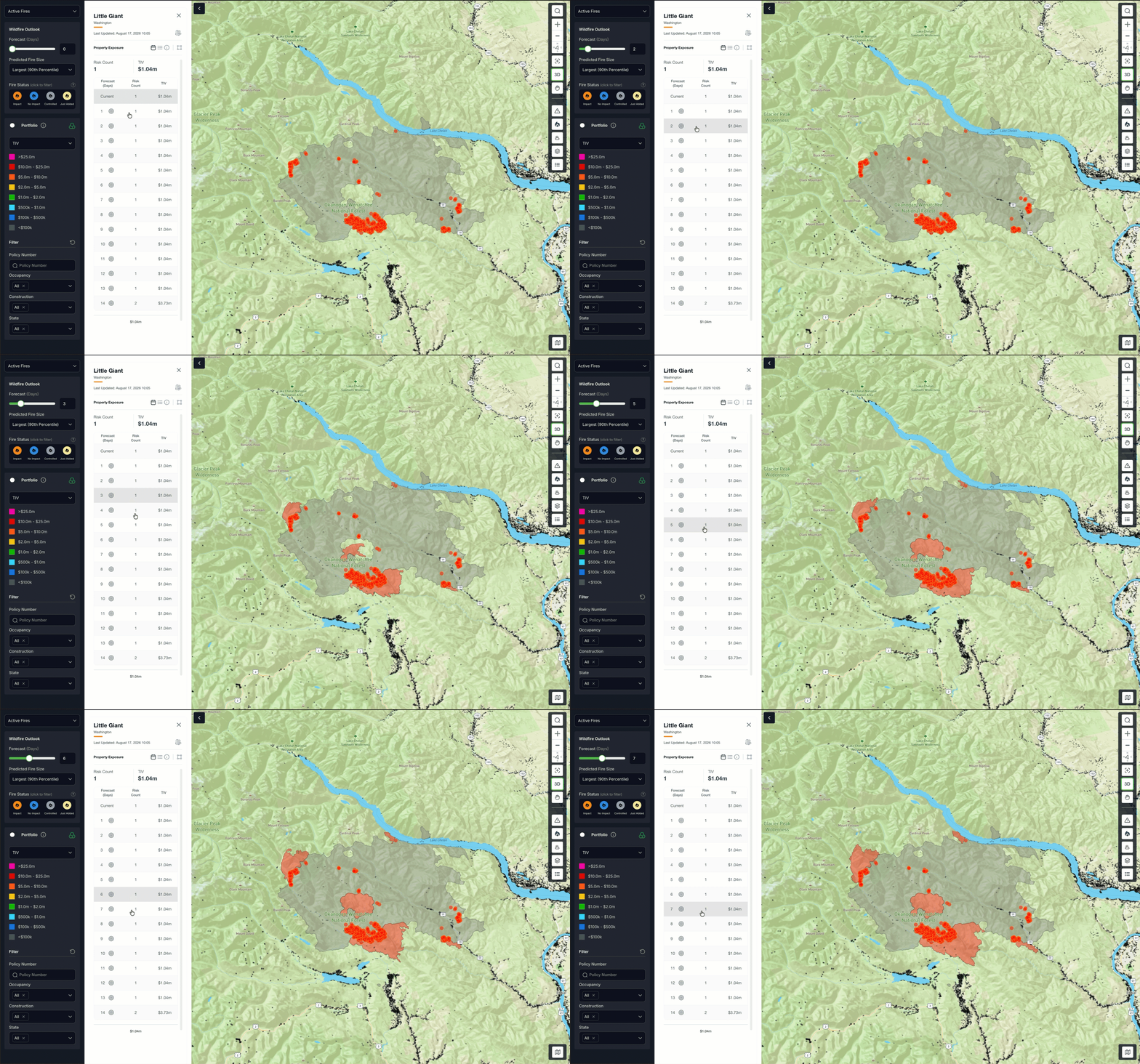
The near-term picture is the concern here. With a heat build and gusty, dry winds forecast over the same slopes this week, fire managers expect continued active behavior and further spread. For underwriters, a fast-moving fire in steep, timbered wildland-urban interface is the classic loss scenario: wind and topography can push fire beyond containment lines and into clustered structures faster than crews can hold them.
Major Fires We’re Watching This Week
The Pacific Northwest continues to dominate the national picture, with Oregon and Washington accounting for the bulk of the country’s uncontained large fires. The fires driving this week’s risk:
- Big Grass (OR): 578,448 acres, 72% contained. The nation’s largest active wildfire, burning across remote Malheur and Owyhee rangeland with Level 3 evacuations still in effect.
- Rowe Creek Complex (OR): 373,784 acres, 89% contained. A sprawling north-central Oregon complex now largely lined after weeks of active growth.
- Sinlahekin (WA): 152,682 acres, 44% contained. North-central Washington’s most active large fire, still only partly contained in Okanogan County shrub-steppe and timber.
- Little Giant (WA): 132,351 acres, 10% contained. The least-contained of the major Washington fires and a focus of this week’s suppression effort.
- Widemouth 2 (UT): 129,741 acres, 80% contained. One of Utah’s largest fires of the season, burning in critically dry Great Basin fuels.
- Aspen Acres (CO): 102,004 acres, 72% contained. Colorado’s largest active fire, reflecting deepening drought across the central Rockies.
What’s driving the backdrop
None of this is happening in a vacuum. A record-thin Great Basin snowpack, roughly 48% of the Lower 48 in drought with the Northwest still deteriorating, and a strengthening El Niño all sit behind the week’s numbers.
For now, the El Niño monsoon is the single biggest swing factor, and it is finally working in the Southwest’s favor.
Regional Risk Outlook
What This Means for Property Owners, Insurers, and Risk Managers
The takeaway for property owners, insurers, and risk managers is really about timing. With the alert level pinned at its ceiling and four western regions above normal, the window to verify exposure and harden assets is now, ahead of the next wind event rather than after an ignition.
Property Guardian’s Overwatch tracks fire behavior, fire weather, and containment in near-real time, so teams can put their attention on the accounts most exposed to this week’s setup. The Southwest’s monsoon relief is real and welcome, but it does nothing to change the math across the Northwest and Great Basin.
Sources
- NIFC National Fire News (active fires, acreage, containment)
https://www.nifc.gov/fire-information/nfn - NIFC Incident Management Situation Report (Aug 16, 2026)
https://www.nifc.gov/nicc-files/sitreprt.pdf - NIFC Statistics (YTD fires and acres)
https://www.nifc.gov/fire-information/statistics - NIFC Predictive Services Outlooks (seasonal/monthly)
https://www.nifc.gov/nicc/predictive-services/outlooks - NOAA Storm Prediction Center Fire Weather Outlooks
https://www.spc.noaa.gov/products/fire_wx/ - National Weather Service Red Flag Warnings (Pendleton/Spokane, OR-WA)
https://forecast.weather.gov/wwamap/wwatxtget.php?cwa=PDT&wwa=red+flag+warning - NOAA CPC 6-10 Day Outlook
https://www.cpc.ncep.noaa.gov/products/predictions/610day/ - NOAA CPC 8-14 Day Outlook
https://www.cpc.ncep.noaa.gov/products/predictions/814day/ - NOAA CPC ENSO Diagnostic Discussion (El Niño advisory)
https://www.cpc.ncep.noaa.gov/products/analysis_monitoring/enso_advisory/ensodisc.shtml - U.S. Drought Monitor / Drought.gov (current conditions)
https://www.drought.gov/current-conditions - NRCS SNOTEL snowpack
https://www.nrcs.usda.gov/programs-initiatives/sswsf-snow-survey-and-water-supply-forecasting-program/snowpack-and
