
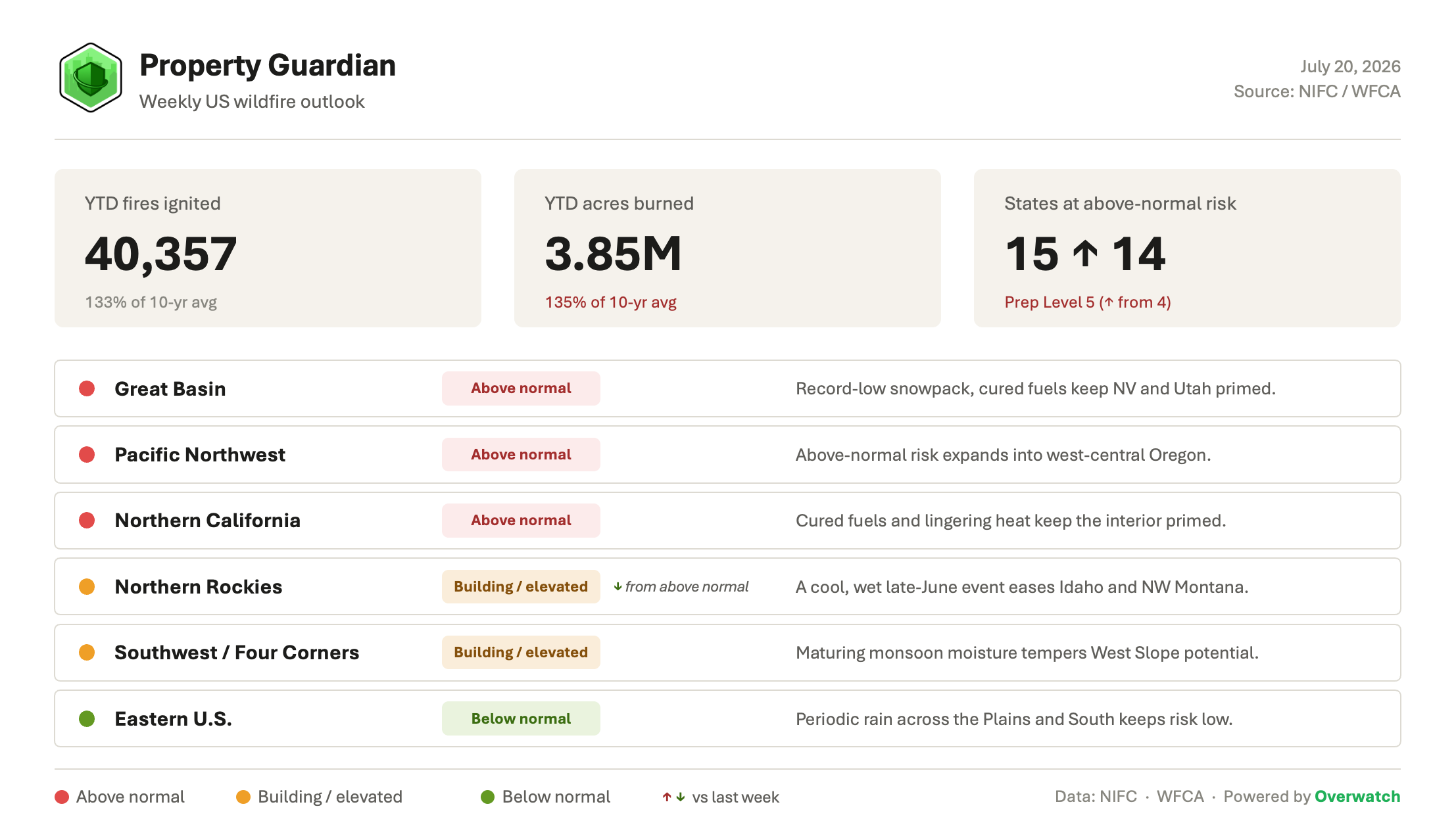
The US enters this week deep in an elevated stretch of fire season: 40,357 fires have already burned 3.85 million acres year-to-date (135% of the 10-year average), and the week ahead opens with the National Preparedness Level at its ceiling and risk still building across the West.
Heading Into This Week
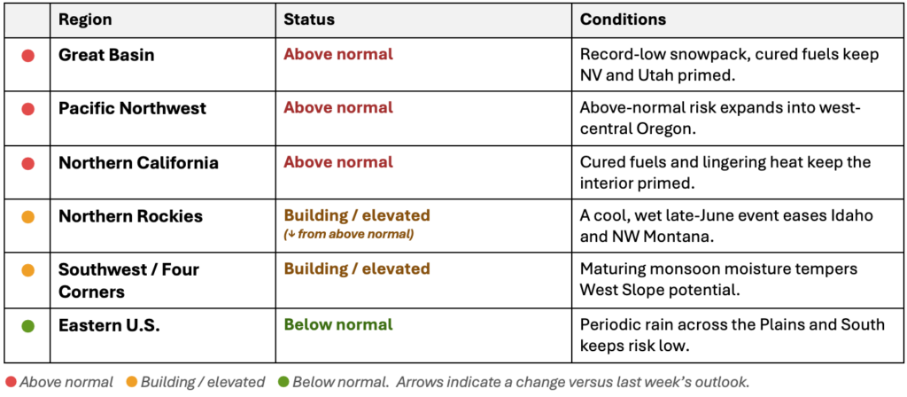
NIFC opens the week at Preparedness Level 5, up from 4, the top of the national scale and its first move to the ceiling this season. States at above-normal risk tick up from 14 to 15 as the season’s northward pivot continues. The Northern Rockies ease from above normal to elevated after a cool, wet late-June event across Idaho and northwest Montana, even as the Pacific Northwest, Great Basin, and Northern California hold firmly above normal.
Major Fires We’re Watching This Week
The week’s risk picture is being driven by a cluster of large, active fires across the interior West, concentrated in Oregon and Nevada:
- Hay Creek Complex (OR) — 103,000+ acres, minimal containment. A lightning-sparked complex of the Hoag, Hopkin, McGinnis, Porcupine Ridge, and Wilcox fires across Gilliam and Sherman counties, with Level 2 evacuations and the Oregon Department of Forestry reporting no remaining available complex incident management teams.
- Hoag Fire (OR) — roughly 50,400 acres, nearing containment. The northern anchor of the Hay Creek Complex has destroyed two homes while crews gain the upper hand.
- Grapevine Fire (NV) — 26,000+ acres, 72% contained. One of several Great Basin fires holding steady as containment builds.
- Kane Springs Fire (NV) — about 17,000 acres. Burning in Lincoln County amid a busy stretch for southern Nevada.
- Parsnip Peak Fire (NV) — 2,265 acres. Part of the cluster of new starts keeping Great Basin resources committed.
What’s Driving the Week Ahead
Conditions still trace back to a record-dry winter and spring. Eight western states, including Nevada, Oregon, Idaho, and Utah, set record-low April 1 snow-water equivalent, and Washington’s snowpack melted out on June 26, roughly three weeks ahead of normal. That early melt has left fuels cured well ahead of schedule, and about 46% of the Lower 48 is now in drought. Building this week is another round of hot, dry, wind-driven weather across the Northwest, where persistent north winds and thousands of recent lightning strikes are still generating new starts.
Further out, an intensifying El Niño in the tropical Pacific favors a near-to-above-normal Southwest monsoon, and maturing monsoon moisture is already tempering fire potential across the Four Corners and Colorado’s West Slope. Meaningful relief for the northern tier, though, is not expected until later in the summer, leaving the weeks just ahead as the most exposed window of the season.
Regional Risk Outlook
What This Means for Property Owners, Insurers, and Risk Managers
For property owners, insurers, and risk managers, a National Preparedness Level at its ceiling and a fifteenth state moving to above-normal risk make the week ahead the time to verify exposure and harden assets, not in August. Property Guardian’s Overwatch platform tracks active fire behavior and shifting risk in near real time so teams can act on the exposed window before conditions peak.
Sources
National Interagency Fire Center (Statistics, National Fire News, Incident Management Situation Report, National Significant Wildland Fire Potential Outlook), Drought.gov, Climate Central, NOAA Climate Prediction Center, and the National Weather Service.
