
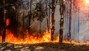
Fire season heads into the final week of August with the Storm Prediction Center flying its highest-tier warning: extreme, or “extremely critical,” fire weather posted over the Columbia Basin and eastern Washington. Nationally, 7.65 million acres have already burned in 2026 across more than 50,200 fires, running near 185% of the 10-year average, and the week ahead opens with the West still firmly in charge.
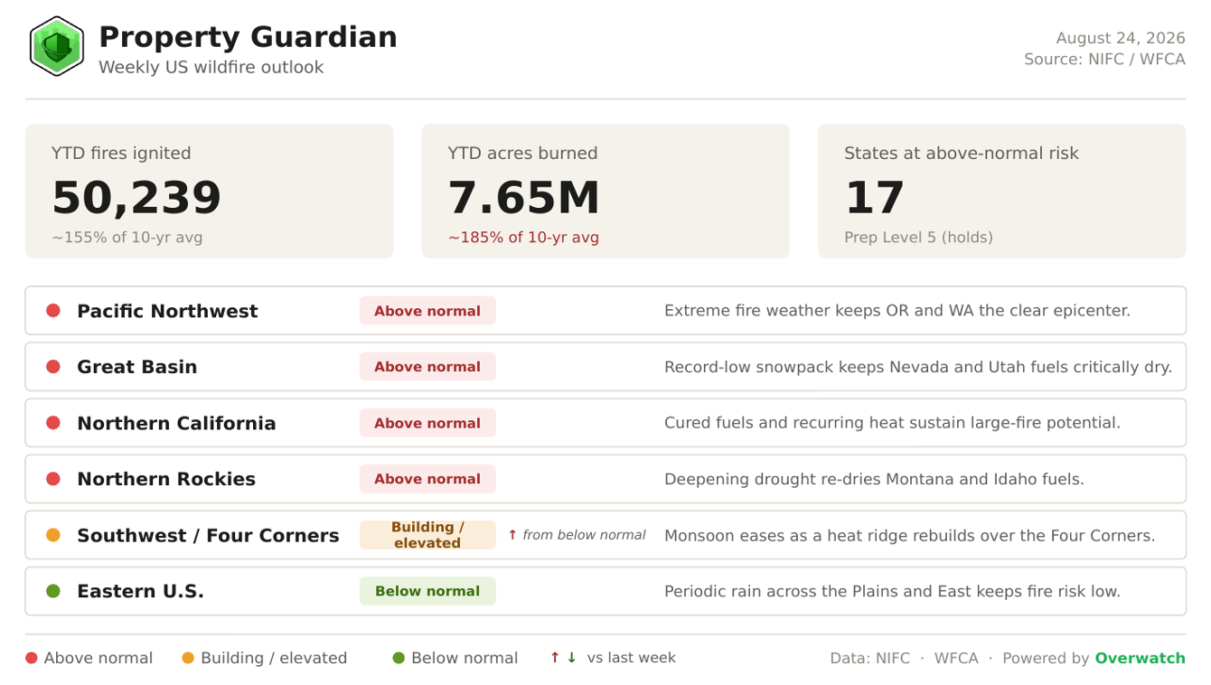
Heading Into This Week
The national picture opens the week largely where it stood. NIFC holds the National Preparedness Level at 5, the top of the scale, where it has sat since mid-July, and the count of states at above-normal significant fire potential holds at 17. Year-to-date totals keep climbing: fires ignited have risen past 50,200 and acres burned have reached roughly 7.65 million, up from about 7.2 million a week ago.
The one regional shift is in the Southwest, where easing monsoon moisture and a rebuilding heat ridge over the Four Corners nudge that zone up from below normal to building/elevated, while the four western above-normal regions hold their tone.
Fire weather for the week ahead
The freshest and most consequential development is near-term.
The Storm Prediction Center has posted its highest fire-weather category, extreme (extremely critical), over the Columbia Basin and portions of central and eastern Washington into north-central Oregon, where dry downslope flow off the Cascades is forecast to drop relative humidity to 15–20% while sustained winds of 20–30 mph gust past 45 mph.
Red Flag Warnings are in effect across central Washington, and gusty afternoon winds, highs in the mid-80s to mid-90s, and single-digit-to-low-20s humidity extend the elevated-to-critical threat across the Great Basin and eastern Northern Rockies.
Farther out, the CPC 6–10 day outlook (valid Aug 25–29) keeps temperatures well above normal across most of the country outside the far West Coast, with an amplified subtropical ridge and extreme-heat risk building over the Southern Plains, Four Corners, and Desert Southwest; the only meaningful wetting signal sits over the Eastern Seaboard and Great Lakes, well away from the fire-risk West.
Fire spotlight
This week’s fire to watch is the Little Giant Fire, burning across Chelan and Okanogan counties in the Washington Cascades.
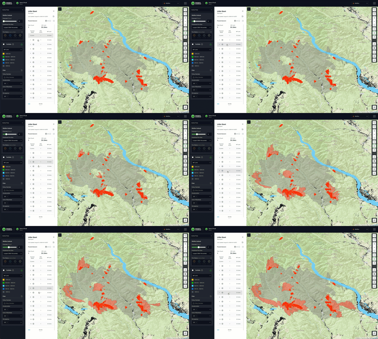
It has spread through remote timber and brush terrain around the Entiat and Chiwawa Rivers, the Glacier Peak Wilderness, and the Lake Chelan drainage to roughly 139,500 acres at just 12% containment, among the least-contained large fires in the country, with crews working to keep it from pushing toward cabins and communities lower in the valleys.
What makes it the marquee concern is timing: the fire sits squarely beneath the week’s extreme fire-weather setup, where downslope Cascade winds gusting past 45 mph and relative humidity near 15–20% can drive rapid, wind-aligned growth on lightly held flanks. For underwriters and risk managers, a fire this large moving into its most dangerous weather window of the season with minimal containment is a clear signal that wildland-urban-interface exposure in central Washington remains live, not resolved.
Major Fires We’re Watching This Week
The largest and most newsworthy fires shaping the week’s risk picture, concentrated across the above-normal West:
- Sinlahekin Fire (WA) – 154,298 acres, 47% contained. Among Washington’s largest active fires, burning northwest of Sinlahekin Campground near Tonasket in Okanogan County.
- Little Giant Fire (WA) – 139,486 acres, 12% contained. Spreading through remote Cascade terrain toward cabins and towns, and heading into an extreme fire-weather stretch with minimal containment.
- Aspen Acres Fire (CO) – 102,004 acres, 77% contained. The eighth-largest wildfire in Colorado history; the human-caused fire near Pueblo destroyed more than 850 structures, including over 330 homes, before crews gained the upper hand.
- Bug Fire (CA) – 93,733 acres, 97% contained. A human-caused fire along the California–Nevada border in Lassen County, now holding with no recent growth.
- Ptarmigan Fire (WA) – 24,720 acres, 55% contained. Burning in the remote Pasayten Wilderness north of the Methow Valley in Okanogan County.
What’s driving the backdrop
Underneath the day-to-day weather, the season’s fundamentals haven’t changed.
The West came out of winter with record-low snowpack, western snow-water equivalent set a record low for April 1 at roughly 65% below the 1991–2020 normal after an early “snow-eater” melt, and about 53% of the Lower 48 remains in drought.
A strengthening, potentially historic El Niño (Niño-3.4 near +2.7°C) is the longer-range wildcard, but the immediate driver is simpler: dry fuels meeting wind.
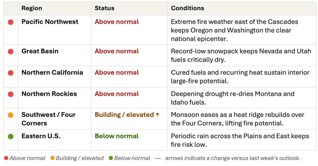
Regional Risk Outlook
What This Means for Property Owners, Insurers, and Risk Managers
For property owners, insurers, and risk managers, the message heading into the week is specificity over season-long generalities.
With the Preparedness Level pinned at 5, a newly building Southwest, and the Storm Prediction Center’s highest fire-weather tier posted over the Pacific Northwest, the next several days, not some hypothetical peak later in the fall, are when exposure should be verified and assets hardened in the highest-risk zones.
Property Guardian’s Overwatch platform tracks these active-fire and fire-weather signals in near real time, so teams can see where risk is escalating and act before conditions turn, not after.
Sources
- NIFC — Statistics (YTD fires & acres)
https://www.nifc.gov/fire-information/statistics - NIFC — National Fire News
https://www.nifc.gov/fire-information/nfn - NIFC — National Significant Wildland Fire Potential Outlook
https://www.nifc.gov/nicc/predictive-services/outlooks - NOAA SPC — Fire Weather Outlook (Day 1)
https://www.spc.noaa.gov/products/fire_wx/fwdy1.html - KATU — Pacific Northwest “extremely critical” fire weather / PDS Red Flag
https://katu.com/news/local/pacific-northwest-faces-extremely-critical-fire-weather-risk-as-winds-near-40-mph-oregon-washington-cascades-pendleton-spokane-bend-redmond-prineville-john-day-madras-pds-red-flag-warning - NOAA CPC — 6-10 day outlook
https://www.cpc.ncep.noaa.gov/products/predictions/610day/ - NOAA CPC — 8-14 day outlook
https://www.cpc.ncep.noaa.gov/products/predictions/814day/ - U.S. Drought Monitor / Drought.gov — current conditions
https://www.drought.gov/current-conditions - NRCS — snowpack / snow water equivalent
https://www.nrcs.usda.gov/programs-initiatives/sswsf-snow-survey-and-water-supply-forecasting-program/snowpack-and - NOAA CPC — ENSO diagnostic discussion
https://www.cpc.ncep.noaa.gov/products/analysis_monitoring/enso_advisory/ensodisc.shtml - Little Giant Fire (spotlight) — KUOW / Okanogan-Wenatchee NF
https://www.kuow.org/climate/2026-08-07/little-giant-fire-spreads-toward-cabins-towns-in-washington-cascades - Named fires — Aspen Acres (Wikipedia), Bug Fire (CAL FIRE), Columbia Basin Herald (WA fires)
https://en.wikipedia.org/wiki/Aspen_Acres_Fire
